Some of you might like to read these 10 entries about the day-to-day life during our 22 day passage from La Paz, Mexico to Hilo, Hawaii. I had posted this on http://farkwar.com/boats/begone (although I didn't fix the technical glitch until halfway through the passage). So I thought I'd post this for any of you who how would like to read (pictures are in other chapters).
Day 2 - Sunday night - 20 April 2015 @ midnight. We departed La Paz at 11:30 AM on Saturday 18 April 2015
. It was a gorgeous, sunny start to our trip. The wind, unfortunately, clocked around to due North (dead down wind for us) and quieted down to 3-8 knots, then due South - so we motor sailed a bit more than we had hoped. We're nearing Cabo San Lucas and looking forward to getting into open blue water. All's great on board.
Day 4 - Tuesday - 21 April 2015 - 0300 UTC - 9:00 PM.
We're all enjoying a postcard perfect Pacific Ocean sail. New moon has just appeared. Our southern route should set us up for a faster/comfortable point of sail we hit the trades.
Today we crossed traffic with 2 Panama Canal bound freighters, have been visited by a school of dolphin and we have apparently been adopted by a Boobie Bird. All's good with us and the boat!
Wind: 10-14 Kts - from the NW, (Occasional 15-20)
Course: ~240 degress - driven by a Monitor Wind Vane
Boat Speed: 5-6.5 kts (have hit 7's)
Sky: Partly cloudy
Day 6 - Thursday night, April 23, 2015 - We are having a fabulous trip. Tonight's dinner was Vicky's Beef Stroganoff with a glass of Malbec Red Wine - yummy. We don't know the temperature since our weather station fritzed so I'll just say it cook and comfortable.
We're sailing straight toward Hilo on a perfect beam reach course of 260 degrees with 2-4 foot seas. Wind: 12-18. Boat speed: 5-7 knots per hour. Our Monitor wind vane is very happy with driving us in these conditions. Made 113 miles good toward Hilo yesterday. Cloud cover has disappeared for now and the stars are out in force. Moon is a sliver and is waxing!
Our watch schedule is 3 hours on -- 6 hours off. Except for this morning when Vicky checked her GPS Watch and discovered we have crossed 2 time zones. Soooo - I had 5 hours on. Oh well. Thanks for keeping up with us - Suzanne, Tom, and Vicky
Day 9 - Sunday, April 26 @ 12:30 AM.
I just got off watch and wanted to update you on our progress. It's possible that our earlier entries were not posted so I made an Airmail format change and hope it works.
We have had rather excellent conditions for this passage thus far. Well, except last night (Friday/Saturday) was rather snotty -- big confused seas, high winds (18-26 kts), everything rolled, banged and rattled, sleeping was impossible plus it was rather damp & chilly (our weather station died so temperature is just an opinion. But today has been splendid!
We have 1835 miles to Hilo. Our GPS thinks we'll get there on the 10th of May. No wait, the 8th of May. No the 12th of May. Oh, we'll get there when we get there!
Food has been terrific. Company even better. We have cocktail hour every evening at 5:00. And nothing has broken that one of us can't fix.
Best to all, Suzanne, Tom and Vicky
Current Wind: 12-18 Knots from the NW
Heading: 250 degrees on a broad reach
Boat Speed: 5-7 knots
Seas: 2-3 ft. swells from the NW
Skies: Cloudy - small waxing moon
location: 19°32.00'N 122°15.00'W
Day 11 - Wednesday, April 29 @ 08:30 PM. (0430 UTC on the 30th)
I just got off watch after our "almost half way" pizza party. It appears that my earlier posts didn't work so I made an Airmail format change and hope this gets through.
Overall, we have had rather excellent conditions for this passage thus far. Well, except for a few nights ago (Friday/Saturday) which was rather snotty -- big confused seas, high winds (20-26 kts), everything rolled, banged and rattled, sleeping was impossible plus it was rather damp & chilly (our weather station died so temperature is just an opinion). But before than and since then, it has been all been splendid!
We have 1345 miles to Hilo. Our GPS thinks we'll get there on the 9th of May. No wait, the 8th of May. No the 12th of May. Oh, we'll get there when we get there!
Food has been terrific. Company even better. We have cocktail hour every evening at 5:00. And nothing has broken that one of us can't fix. Today's big fix was end for ending the spectra line on our Monitor wind vane in 20 knots of wind. We got to practiced heaving to and splashing Tom as he hung over the back of the boat. A wire fastening on one of the blocks had broken 2 days ago and the pulley started chaffing the line. Tom fixed the block but we knew the line wouldn't last long. So we fixed it today so we didn't have to fix it tonight!
Tom says "Next time I drive across Texas it's going to feel like Rhode Island." He's just missing the Grandkids and his kids and Club Tac and fixing motorcycles. We're all on our 2nd or 3rd book!
Best to all, Suzanne, Tom and Vicky
Current Wind: 20 Knots from the WNW
Heading: 260 degrees on a broad reach
Boat Speed: 6.5 knots
Seas: 3 ft. swells from the NW
Skies: Very Cloudy. Nice squalls bring some extra wind and occasional light rain. Waxing moon
location: 19°49.00'N 131°13.00'W
Day 14 - Friday, May 1, 2015 @ 0312 GMT / 6:30 PM in our little spot in the ocean!
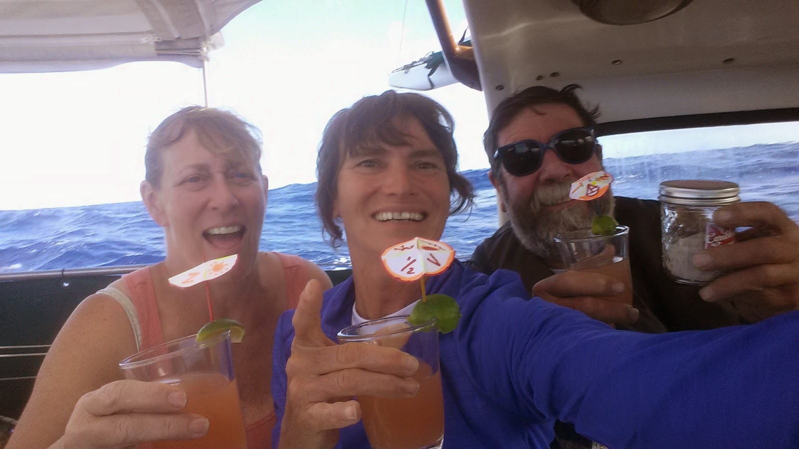
Tom said "next time I drive across Texas, it's going to feel like Rhode Island!. Yes, indeed, it's quite a long passage to Hilo. Yesterday was our half way (in mileage) party! Cocktail hour with personalized drink umbrellas, amazing fillet steak with cucumber/sprouts/tomato salad and fried sweet potatoes a la Vicky! We enjoyed a reasonably quiet dinner and then went back to Squall Busting! Today, has been a picture perfect day with a brilliant blue ocean and blue skies with puffy white cumulus clouds.
We are in daily contact via VHF radio with the 34' Catamaran "Popoki" (Hawaiian for "cat") also bound for Hilo. They're just 30 miles ahead of us so we've enjoyed chatting with them and sharing weather and fishing reports.
Course: 260 True
Speed: 5.5 knots
Wind: 12-15 knots
Distance to Hilo: 1080 Miles
----
At 5/2/2015 3:10 AM (utc) our position was 19°49.00'N 135°56.00'W
Day 17 - Monday, May 4, 2015 - 0300 UTZ / 3:30 in the afternoon our time!
Greetings,
Last night I called up "hey, Vicky, could you dim that moonlight, we're trying to sleep down here". The only solution she came up with to cloud the skies with 22-28 knot squalls that clouded the skies and stirred the seas.
Not a good night for sleeping. But is was a great night for Begone to show what she can do. It amazes me how she glides (and sometimes charges) through a confused set of waves and gusts of wind with the help of our trusty Monitor Wind Vane.
All's good on board. Vicky's finished her 4th book. Tom and I will start our 4th books later today.
Only 700 miles to Hilo and hot showers!
Heading: 275 True (we're a little higher on the course than we wished, but hey, it's where the wind blows!)
Wind: 20 knots ENE
Seas: 4-10 Feet
Yesterday we made 134 miles good so we if this all holds, we could be in Hilo in 6 days!
At 5/5/2015 12:32 AM (utc) our position was 20°23.00'N 142°35.00'W
Day 20 -Thursday, May 7, 2015. 0118 UTC/3:19 PM Hawaii time.
Well, we thought it might take 23 days to get to Hilo -- and we'll probably get in right around then. It was looking like we would be earlier, but there has been too much north in the northeast breeze (usually 20+ knots) plus we had a nightly parade of big squalls (usually during Suzanne's watch) with lots more velocity and sucking us further north. As a result we're up at 21.5 degrees latitude instead of down at 19.4 degrees. Rats.
So today, we had a crew meeting. Should we:
1) Jibe south now (that would probably point us toward Chile as it did when we tried it yesterday)
2) Hold our course and get closer to the islands and watch for the wind to get more East in it -- then jibe
3) Forget Hilo...let's go to Maui.
For today and tonight we chose option #2. But stay turned. Who knows, tomorrow we could decide to go to Maui or heck, maybe just head on to Japan!
Still having fun and eating well and reading lots of books, answering questions from "the little book of stupid questions" and occasionally fixing stuff when it breaks which makes Tom happy.
-----
At 5/8/2015 1:07 AM (utc) our position was 21°52.40'N 149°18.00'W
Day 20 - Friday evening, May 8, 2015 7:25 PM Hawaii time
At our 0900 watch change this morning, we decided to jibe toward Hilo. And just like magic, our GPS said we were right on track to make Radio Bay, Hilo late Sunday afternoon. Now a lot can happen between now and then, but we enjoyed a fabulous "getting close to Hilo" dinner of beef filet and sweet potato/white potato mash and red wine -- created by Chef Vicky. Awesome, indeed!
We're sailing on a nice broad reach - 235 degrees True. The wind is only about 16-18 knots now out of the ENE (but more East than we've seen in 2 weeks). Seas have set down and there are no squalls on the horizon - yet.
If If If. If we can keep going ~5 knots toward Hilo (222 miles away) at a course of 238 degrees, we could be there for dinner on Sunday early evening. We'll keep you posted!
-----
At 5/9/2015 4:26 AM (utc) our position was 21°40.00'N 151°38.00'W
Day 22 - Sunday, May 10, 2015 - 4:00 PM
We arrived in Hilo on a beautiful mild overcast day -- wind dropped down to 15 knots, the squalls settled down and all that North in the ENE breeze clocked more East! So into Hilo Bay we came - 22 days and 5 hours out of La Paz. 19 days out of Cabo.
Now it's Wednesday -- and I'm finally updating our Farkwar map.
Our first night here we anchored in Reed's Bay (a "neighborhood" of Hilo Bay) next the catamaran "Popoki" who we had kept in VHF radio contact for almost half our trip (lost them in the last 4 days so were happy to see them). Reed's Bay has poor holding - mud over lava rock. But the Carnival Cruise Ship was blocking the tiny entrance into Radio Bay (100 yards clearance is required without Coast Guard clearance). So on Monday morning, we got up and moved here - where we are now along with 8 other transient boats.
We plan to be here at least a week. I'll be updating our Blog - svbegone.blogspot.com
Gee but it's great to have our hook down!
Suzanne, Tom and Vicky
-----
At 5/10/2015 1:43 AM (utc) our position was 20°32.00'N 153°17.00'W
AND HERE WE ARE!!!


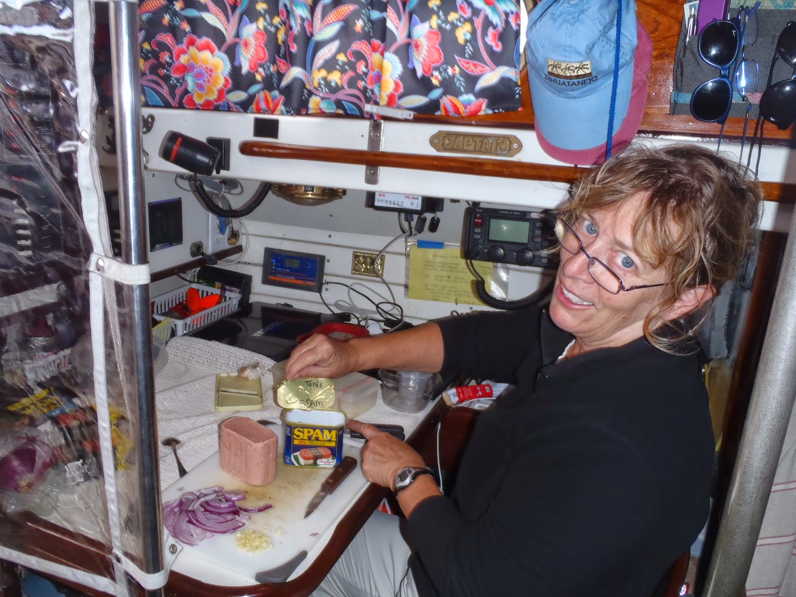
 For the night before the 1/2 way party, Suzanne made Pizza's. Toppings included mushrooms, black olives, onion, garlic, cheese, and TOM wanted SPAM. Go figure!