Wednesday, June 24, 2015

Begone Goes Hawai'ian Style - Part II

Part II takes us from Hawai'i to Oahu via Maui.
Leaving the Big Island was difficult -- we really enjoyed the diversity of the land, the people and things to do.  But deciding WHEN to leave was a rather easy decision,  To make our way up to Maui, we just needed a 24 hour sail across the DREADED Alenuihana Channel.  This crossing is positively legendary for intense winds and high seas and for breaking boats.  But of all the luck, the days we chose to cross, we had flat seas and very light wind.  It was a gift!
Another beautiful Sunrise in paradise

Maui -- for 3 nights, 2 anchorages, some friends and an E Ticket Dinghy Dock...
The rarely visited south shore of Maui


Our first night on Maui we chose to anchor at Oneuli "White Sand" Beach.  There hill provided protection from the NW 20 knots of breeze.  Surfers were enjoying some good breaking waves so we chose to watch the beach goers from the boat rather than swamp our dinghy trying to go ashore. 

We got up the next morning and headed for Lahiana hoping to meet up with our friends from Crockett, CA -- Louise and Rob McClendon who were visiting Maui.  The nice 20 knots of breeze on the beam faded to calm just as we noticed a boat we had met in Radio Bay -- and we had the jacket he left at the party.  It was an impressive and successful hand-off at sea with Vicky on boat pole, Tom at the helm and Suzanne at the camera!  

We continued North to Lahiana -- and the wind proceeded to build to 30 knots.  Our friends on "Popoki" were anchored in good holding ground in the Mala Wharf beach - 1 mile north of Lahiana.  So we chose to anchor rather than trying to pick up a mooring ball at the Yacht Club.  It was a gusty anchorage, but we were confident that Begone was well stuck (Thank you John and Dorothy for choosing a big 45 lb. anchor!)

The next morning, the NE 20+ knots of wind continued, but we wanted to meet Rob & Louise on shore -- so we launched the dinghy and headed to what is generally a calm launch ramp/dinghy dock.  BUT NOT TODAY.  You may be able to see the waves breaking in the entrance -- it was an 
E-Ticket ride and tie-up.


It was great to catch up with Rob & Louise and enjoy lunch on the waterfront.  It was too snotty to bring them out to Begone so we said our "good-byes - see ya in Crockett" and headed back to the rock and rolling at the anchorage,  We decided that spending more time on Maui would have to be another trip.  The wind was blowing and Oahu was calling us.  The next morning we weighed anchor and headed for Honolulu.

Three Week on Oahu -- Begone is side-tied to the Aloha Deck of the Hawaii Yacht Club (Waikiki/Honolulu).   


This was taken from a plane ride (more late) -- Begone is right in the middle of the picture.

We were warmly welcomed at the Hawaii Yacht Club.

 And enjoyed the canoe'ers and SUP'ers and rowers go by us everyday.


We had met John Tebbetts (Ichi Ban) in San Carlos in 2013 and have enjoyed (hated) getting together with him ever since.  We wanted to get to Honolulu before he took off sailing to the South Pacific.  We shared several get togethers (and paid off our Super Bowl pizza bets) before his departure.  Fair winds, John!


\
SPAM continues to be on our shopping list -- Tom's new favorite is Black Pepper SPAM

Tom had to do a motorcycle trip of the island -- so chose a Triumph for his wheels this time. 


Our favorite boat neighbor - "Redford" and his owner Steve is AOK, too.


Before we left Honolulu, we invited a few friends over for appetizers and beverages.  Begone managed to accommodate 13 people and Redford!  Turns out that's just enough weight in the cockpit to allow 2 inches of water in through the cockpit drain!

We decided to add AIS to our navigation/safety gear...Tom engineered a beautiful mount. 

Things we did during our weeks on Oahu:

Vicky had met Merle and Mary (Tirnanog) when she and Chuck were sailing in the South Pacific.  Merle is now the caretaker and chief pilot for Hawaiian Airlines 1st commercial plane - a 1929 Bellanca.  What an amazing ride we had!


Pilot to Co-Pilot -- NOT!  Merle and Tom had the cockpit covered!

And then there's Vicky's Epic Run on the "Stairway to Heaven" Trail...a 5 hour run with a major elevation demand.  Was this from a plane or on foot?  ON FOOT!  Amazing - so she did it twice in 24 hours!

And then there were parties on Begone -- one night we had a party with 13 people aboard and a good time was shared by all -- despite the stern was so low that 2 inches of water came up through the cockpit drain!  

It was a fun and eventful 3 weeks on Oahu.  But it was time to leave for Kauai on Monday, June 15th.  We were looking forward to our trip to Hanalei Bay, Kauai.  So off we went!
But had a Mai Tai with our friends at the Royal Hawaiian Mai Tai bar on the beach as our send off!

Chapter 3 -- Kauai


Monday, June 15, 2015

Begone goes Hawaiian Style - Part I

Part 1 of a 3 part series on Begone Cruising the Hawai'ian Islands!

We arrived in Hilo on the big Island of Hawai'i on Sunday, May 10th.  But now it's June 18th and it's taken me over an month to make time to update our blog.  A while ago, it dawned on me that most people come to the islands with a return plane ticket (or to work or to retire).  We were able to come and enjoy being here with only a vague departure idea based on inclinations and weather.  We also had people we wanted to see, places we wanted to go, and mountains Vicky needed to run.

So here's the first section of our travelog starting on May 10th.
We anchored in the rather small but well protected Radio Bay, Hilo.  Radio Bay is in the industrial section of Hilo with the Cruise Ships, Cargo Ships and a lot of Homeland Security presence.  There is a nice shower house/covered picnic area/book exchange/fresh water facility for cruisers.  To go into town, we rowed our dinghy to the beach of the paddling club, then a walk past the water treatment facility and up to a rather busy road. We decided to rent a car for a week which worked out perfectly as we were able to cover most of the island during that time.
Tom had been hoping to see the C&H Sugar sign that he had remembered from sailing to Hilo in 1991.  But alas, the only C&H sign remaining is just three miles from our home in Port Costa -- Crockett.  Almost all sugar interests in these islands were sold in 1993 to Alexander & Baldwin, Inc. and the "H" in C&H no longer originates in Hilo.  
Kids from the traditional canoe rowing club enjoying an after row dip in the Bay!

We enjoyed meeting the cruisers on the 6 other boats who came in about the same time as us and stayed about as long as us (~10 days).  It was $9.10 a night plus a $17 initiation fee...but you had to pay with a cashiers check (no cash, credit card or check) which want an occasional visit to the Payday Loan shop.  Crazy or amusing!
A fun potluck dinner for all us Radio Bay'ers...the party went well past cruisers midnight!

All of these people we have continued crossing tacks with up the islands.


One raining morning, Vicky and I hiked along the shoreline in search of the 
Hilo Yacht Club (about 2 miles south of Radio Bay). We brought Tom back for a very nice dinner and were warmly welcomed. We exchanged our Point San Pablo Yacht Club burgee for a Hilo YC one.  The unprotected windward location of HYC made it impossible to anchor or place a marina. So HYC is more of a social/swimming/tennis club than a boaters club.  But hey any good reason to get together in a beautiful setting!

Things to fix, places to go and people to see!
Vicky up the mast -- this time to discover our jib halyard was seriously chaffing!
We stopped in Captain Cook at a Car Repair/Machine shop so that Tom could make replacement parts for our mainsail batten that had lost it's plug.
We had a terrific afternoon/evening/morning with longtime cruising and Sausalito friends Dawn and Jeff Stone who now live on Hawai'i.

And on the South Shore, we had to stop at Shaka's Restaurant for a beverage at 
"The Most Southern Bar in the USA"
No trip would be complete without a trip to the Recycling and Transfer Station -- actually it was the closest we could get to the most recent and active lava flow.


The Big Island with Plush tropical terrain, Mountains, Volcanoes and Lava Rock
This is the tropical paradise viewed from the windward side of Hawai'i.
As you travel West and Inland, the waterfalls and mountainous terrain unfold.


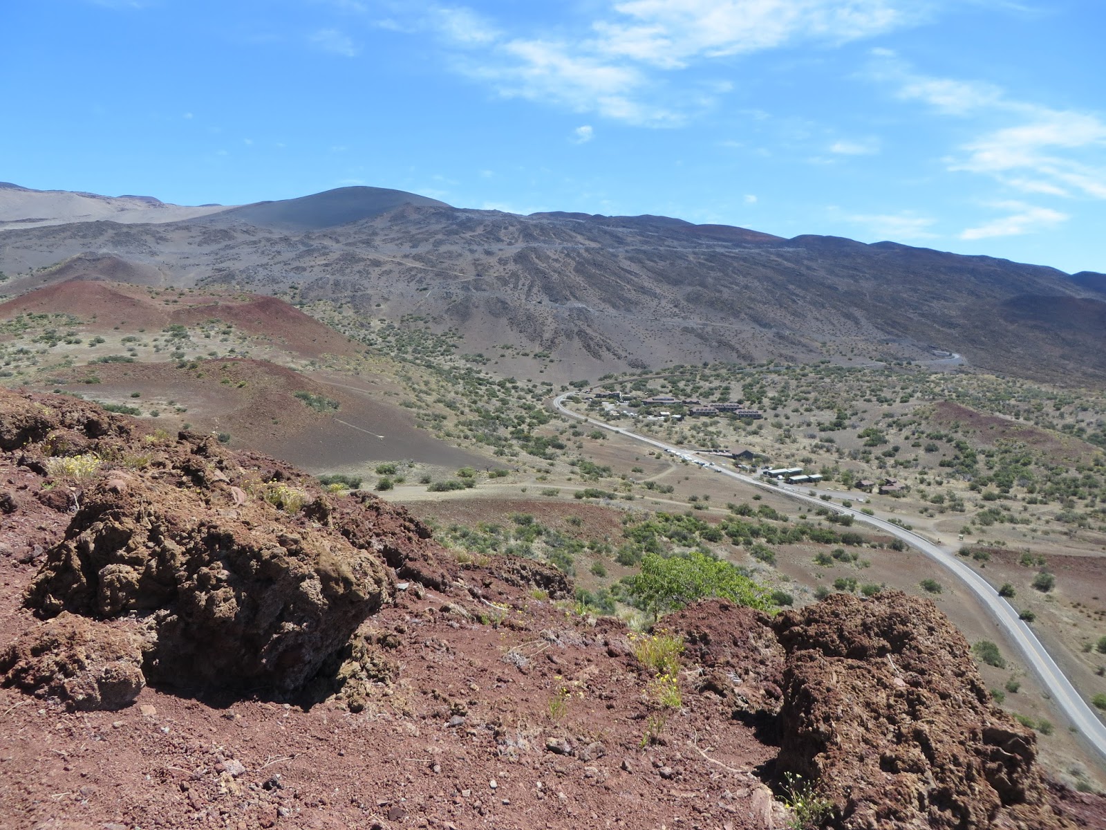
Vicky shot this looking down from Mauna Kea's observation trail (9,200 ft above sea level) during a little run from the ranger station.  The top of Mauna Kea is the location of some of the most powerful telescopes on Earth.  Scientists are searching for what ever is out there in the beyond.  The mountain rises 13,700 foot high above sea level, It feature snow much of the year and offers international scientist a clear view of the heavens with no competition from city lights or atmospheric disturbance. 

And on the Southeast side of the Big Island... 
There's active Volcanoes!  We visited Volcano National Park and looked over steaming craters and walked through lava tubes. 


Lava is a story all to itself -- here's a couple interesting pictures.
This is from the 2010 lava flow the wiped out a large area of the SE corner of the island.

This is the house that "the Lava Man" rebuilt a small home over his land/home that had been completely destroyed and covered by lava in the 2010 flow.  And do you like his toilet? See below. 
\
New life pushes through these lava rocks.  It's rather amazing.


On Wednesday, June 20th, the weather window invited us to weigh anchor and head up the island chain,  Part II of this Hawaii portion of  Begone's Blog will cover our short time in Maui and 3 weeks on Oahu.   Aloha!


Tuesday, May 19, 2015

Aloha, Hilo, Hawai'i - Arrived on May 10, 2015

Tom, Vicky and I (Suzanne) have done our fair share of off shore passages -- Tom has sailed back and forth from Hawai'i, Suzanne's raced and cruised to and from the islands several times, and Vicky has sailed all through the South Pacific Islands (although never to Hawai'i).

What makes this passage so unique is "BEGONE" herself and the friends that are woven in her story.  We've all three known and loved her for many years.  She represents the engineering, creating and sailing talents of John & Dorothy Kiesling, Vicky & Chuck Levdar (and Frans Maas the designer/builder in 1961).  Our dear friends, Matt & Jeannine Herron had purchased Begone in 1980's.  When they were ready to find a new caretaker for Begone, Vicky & Chuck were instrumental enticing John & Dorothy to take on the challenge of restoring Begone - which they did from 2002 to 2005- then cruised her in Mexico for 5 years.  Then Tom & Suzanne became her caretaker in 2010.  So this feels like a "may the circle be unbroken" passage.
Begone in rainy Radio Bay, Hilo, Hawai'i

The PASSAGE - 
We thought it would take 23 days for our La Paz to Hilo passage...we made it in 22.  It was actually 19 days from Cabo San Lucus to Hilo as we decided to make a stop for additional diesel given that we used a bit more than we anticipated in the day and a half from La Paz.
We anorchored off the coast of Cabo San Lucas for a little sleep and then motored in for fuel.

Guess what?  Cabo San Lucas (reportedly one of the most expensive marinas in the world) charged us $80 US - just to tie up to their fuel dock.  We just laughed ourselves silly and paid the $182 bill.
Cabo San Lucas fuel dock -- $80 US for 20 minutes-- Really??!!!
After pulling out of port, we went to turn on our Radar / Chart Plotter for navigation.  The screen went black.  Our major navigation tool had died.  I tried all my tricks, Tom and Vicky looked at me as if they thought I could fix this.  I got us going with our handheld Garmin GPS and went back to tackle the problem.  Using the manual,  ran the tests and all systems worked except for the screen was black.  Tom and Vicky still looked at me as if I should be able to fix it.  So back I went to the manual and found that  (like other tech things) was a reboot which I applied -- and YEA - she lit up like a top and got us to Hilo.  We renamed it our "Chuck Plotter" (cause I know the spirit of Chuck was just messin' with us).

LIFE ONBOARD UNDERWAY

We had prepared 16 days of fabulous dinners and froze them in La Paz.  
Plus we all loved Vicky's Pancakes!

There was often something to fix. Our watch schedule was 3 hours on and 6 hours off.  It worked quite well for us to allow time to rest, read, recharge -- yet be ready for any "all hands on deck".
We did not have hot water -- nor a shower.  So hair washing was either in the sink - or out on deck.  

This is Vicky in the "Phone Booth" -- talking via Satellite phone with her Mom in Kansas!  We needed a sat phone for emergencies -- but when we got to the end of the month and had minutes left, we just called our business managers, friends and family for 10 minutes!

Farm Living -- Vicky's sprout farm.  Cabbage, Carrots, Beets, Jicama, and these sprouts kept us in fresh produce for the whole trip.
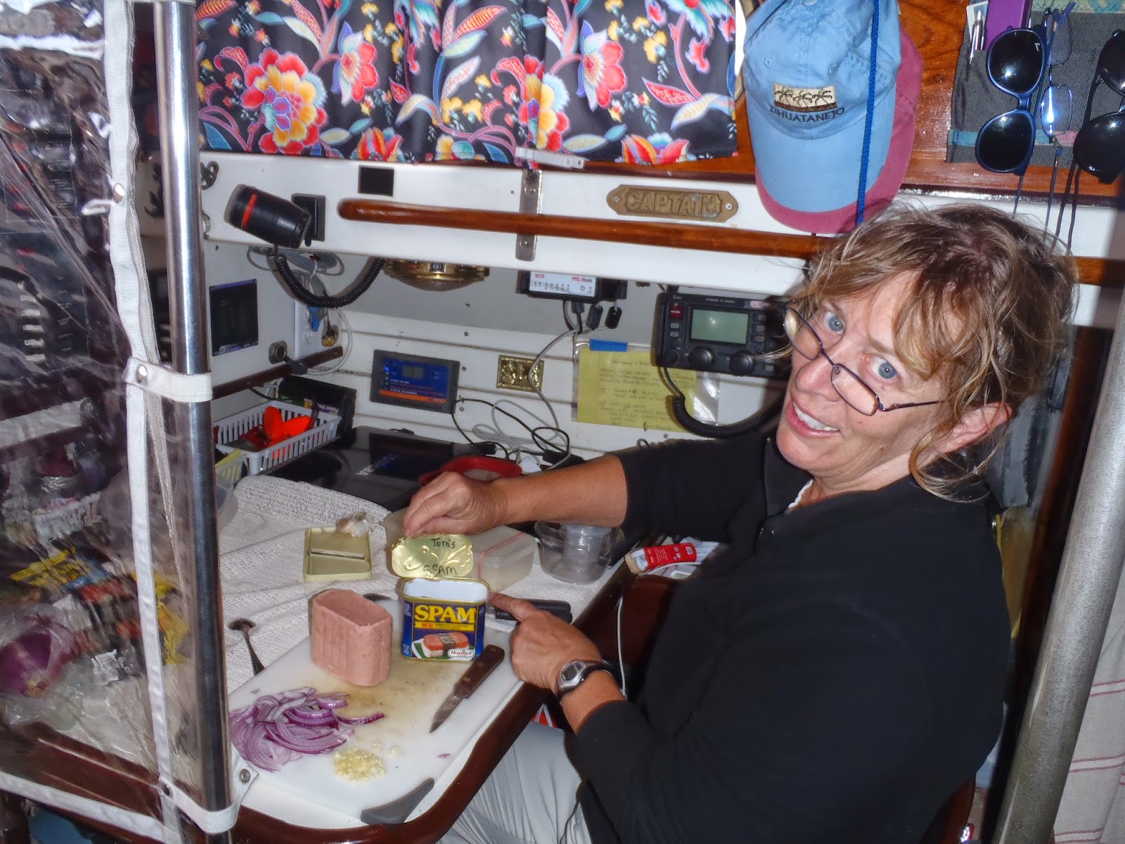
For the night before the 1/2 way party, Suzanne made Pizza's.  Toppings included mushrooms, black olives, onion, garlic, cheese, and TOM wanted SPAM.  Go figure!
Tom's Tongue de SPAM


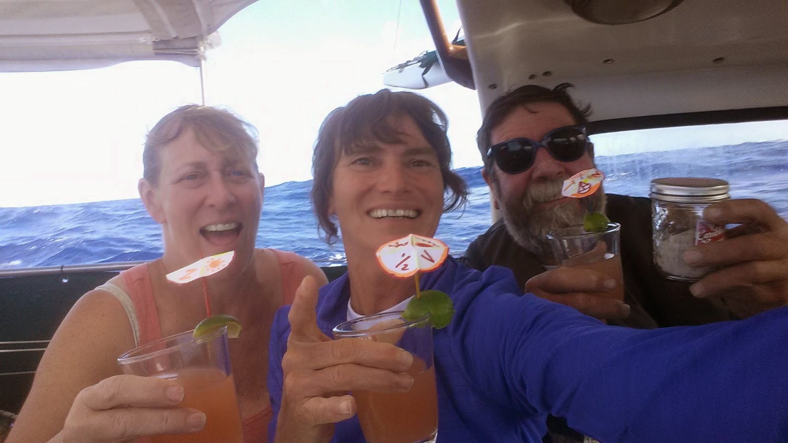
Halfway party complete with umbrellas for the beverages and John in his cups.  Lasagna was on the dinner menu!

It looks like a calm night!
But in the morning, Vicky toured the deck and found us a flying fish -- not quite big enough to eat.  We actually did drag a line for a couple days but alas, didn't get a bite.

You can see on the horzon that we are passing near a large ship.  On watch, we scan the horizon about every 10 minutes -- looking for ships, squalls and any trouble on deck.  With this ship, I called out on the VHF to confirm that they saw us on their radar.  I was tracking them on ours.  It was an nice conversation -- they were bound for the Panama Canal.  We crossed with 4 ships and 1 sailboat (Popoki) during the passage

We are grateful to Jessica (List) & Joel Steffan for taking care of our 15 year old dog, Sasha.  This trip would have been impossible without their help -- but Vicky did bring the the spirit of the 'ole girl along for the trip.

No ocean voyage would be complete without a few pictures of sun rises and sunsets - we had 22 of them - but here are a few:


A Rainbow after a big Squall


Can you see the full moon just to the right of the Monitor Wind Vane?  It lit up the night in the most beautiful way!


And this is a little video of us underway - probably not a good one if you're prone to sea sickness.


The next entry will be about life on land!


Passage Log - La Paz, Mexico to Hilo, Hawaii

Some of you might like to read these 10 entries about the day-to-day life during our 22 day passage from La Paz, Mexico to Hilo, Hawaii.  I had posted this on http://farkwar.com/boats/begone (although I didn't fix the technical glitch until halfway through the passage).  So I thought I'd post this for any of you who how would like to read (pictures are in other chapters).

Day 2 - Sunday night - 20 April 2015 @ midnight.  We departed La Paz at 11:30 AM on Saturday 18 April 2015.  It was a gorgeous, sunny start to our trip.  The wind, unfortunately, clocked  around to due North (dead down wind for us) and quieted down to 3-8 knots, then due South - so we motor sailed a bit more than we had hoped.  We're nearing Cabo San Lucas and looking forward to getting into open blue water.  All's great on board.

Day 4 - Tuesday - 21 April 2015 - 0300 UTC - 9:00 PM.  
We're all enjoying a postcard perfect Pacific Ocean sail. New moon has just appeared. Our southern route should set us up for a faster/comfortable point of sail we hit the trades. 

Today we crossed traffic with 2 Panama Canal bound freighters, have been visited by a school of dolphin and we have apparently been adopted by a Boobie Bird.  All's good with us and the boat!
Wind: 10-14 Kts - from the NW,  (Occasional 15-20)
Course:  ~240 degress - driven by a Monitor Wind Vane
Boat Speed:  5-6.5 kts (have hit 7's)
Sky: Partly cloudy

Day 6 - Thursday night, April 23, 2015 - We are having a fabulous trip. Tonight's dinner was Vicky's Beef Stroganoff with a glass of Malbec Red Wine - yummy. We don't know the temperature since our weather station fritzed so I'll just say it cook and comfortable. 
We're sailing straight toward Hilo on a perfect beam reach course of 260 degrees with 2-4 foot seas. Wind: 12-18. Boat speed:  5-7 knots per hour.  Our Monitor wind vane is very happy with driving us in these conditions. Made 113 miles good toward Hilo yesterday. Cloud cover has disappeared for now and the stars are out in force.  Moon is a sliver and is waxing!  
Our watch schedule is 3 hours on -- 6 hours off.  Except for this morning when Vicky checked her GPS Watch and discovered we have crossed 2 time zones.  Soooo - I had 5 hours on.  Oh well.  Thanks for keeping up with us - Suzanne, Tom, and Vicky

Day 9 - Sunday, April 26 @ 12:30 AM.
I just got off watch and wanted to update you on our progress.  It's possible that our earlier entries were not posted so I made an Airmail format change and hope it works.
We have had rather excellent conditions for this passage thus far.  Well, except last night (Friday/Saturday) was rather snotty -- big confused seas, high winds (18-26 kts), everything rolled, banged and rattled, sleeping was impossible plus it was rather damp & chilly (our weather station died so temperature is just an opinion.  But today has been splendid!

We have 1835 miles to Hilo.  Our GPS thinks we'll get there on the 10th of May. No wait, the 8th of May. No the 12th of May.  Oh, we'll get there when we get there! 
Food has been terrific.  Company even better.  We have cocktail hour every evening at 5:00.  And nothing has broken that one of us can't fix.  
Best to all,  Suzanne, Tom and Vicky

Current Wind:  12-18 Knots from the NW
Heading:  250 degrees on a broad reach
Boat Speed: 5-7 knots
Seas: 2-3 ft. swells from the NW
Skies: Cloudy - small waxing moon
location:  19°32.00'N 122°15.00'W

Day 11 - Wednesday, April 29 @ 08:30 PM. (0430 UTC on the 30th)
I just got off watch after our "almost half way" pizza party. It appears that my earlier posts didn't work so I made an Airmail format change and hope this gets through.

Overall, we have had rather excellent conditions for this passage thus far.  Well, except for a few nights ago (Friday/Saturday) which was rather snotty -- big confused seas, high winds (20-26 kts), everything rolled, banged and rattled, sleeping was impossible plus it was rather damp & chilly (our weather station died so temperature is just an opinion).  But before than and since then, it has been all been splendid!

We have 1345 miles to Hilo.  Our GPS thinks we'll get there on the 9th of May. No wait, the 8th of May. No the 12th of May.  Oh, we'll get there when we get there! 
Food has been terrific.  Company even better.  We have cocktail hour every evening at 5:00.  And nothing has broken that one of us can't fix. Today's big fix was end for ending the spectra line on our Monitor wind vane in 20 knots of wind. We got to practiced heaving to and splashing Tom as he hung over the back of the boat.  A wire fastening on one of the blocks had broken 2 days ago and the pulley started chaffing the line. Tom fixed the block but we knew the line wouldn't last long.  So we fixed it today so we didn't have to fix it tonight!   

Tom says "Next time I drive across Texas it's going to feel like Rhode Island."  He's just missing the Grandkids and his kids and Club Tac and fixing motorcycles.  We're all on our 2nd or 3rd book!  
Best to all,  Suzanne, Tom and Vicky

Current Wind:  20 Knots from the WNW
Heading:  260 degrees on a broad reach
Boat Speed: 6.5 knots
Seas: 3 ft. swells from the NW
Skies: Very Cloudy. Nice squalls bring some extra wind and occasional light rain.  Waxing moon
location:  19°49.00'N 131°13.00'W

Day 14 - Friday, May 1, 2015 @ 0312 GMT / 6:30 PM in our little spot in the ocean!
Tom said "next time I drive across Texas, it's going to feel like Rhode Island!.  Yes, indeed, it's quite a long passage to Hilo. Yesterday was our half way (in mileage) party!  Cocktail hour with personalized drink umbrellas, amazing fillet steak with cucumber/sprouts/tomato salad and fried sweet potatoes a la Vicky!  We enjoyed a reasonably quiet dinner and then went back to Squall Busting!  Today, has been a picture perfect day with a brilliant blue ocean and blue skies with puffy white cumulus clouds.

We are in daily contact via VHF radio with the 34' Catamaran "Popoki" (Hawaiian for "cat") also bound for Hilo.  They're just 30 miles ahead of us so we've enjoyed chatting with them and sharing weather and fishing reports.  

Course: 260 True
Speed: 5.5 knots
Wind: 12-15 knots
Distance to Hilo: 1080 Miles
----
At 5/2/2015 3:10 AM (utc) our position was 19°49.00'N 135°56.00'W


Day 17 - Monday, May 4, 2015 - 0300 UTZ / 3:30 in the afternoon our time!
Greetings,
Last night I called up "hey, Vicky, could you dim that moonlight, we're trying to sleep down here".  The only solution she came up with to cloud the skies with 22-28 knot squalls that clouded the skies and stirred the seas.  
Not a good night for sleeping.  But is was a great night for Begone to show what she can do.  It amazes me how she glides (and sometimes charges) through a confused set of waves and gusts of wind with the help of our trusty Monitor Wind Vane.  

All's good on board. Vicky's finished her 4th book.  Tom and I will start our 4th books later today.  

Only 700 miles to Hilo and hot showers!

Heading: 275 True (we're a little higher on the course than we wished, but hey, it's where the wind blows!)
Wind:  20 knots ENE
Seas:  4-10 Feet
Yesterday we made 134 miles good so we if this all holds, we could be in Hilo in 6 days!

At 5/5/2015 12:32 AM (utc) our position was 20°23.00'N 142°35.00'W


Day 20 -Thursday, May 7, 2015. 0118 UTC/3:19 PM Hawaii time.
Well, we thought it might take 23 days to get to Hilo -- and we'll probably get in right around then.  It was looking like we would be earlier, but there has been too much north in the northeast breeze (usually 20+ knots) plus we had a nightly parade of big squalls (usually during Suzanne's watch) with lots more velocity and sucking us further north. As a result we're up at 21.5 degrees latitude instead of down at 19.4 degrees.  Rats.   
So today, we had a crew meeting. Should we:
1) Jibe south now (that would probably point us toward Chile as it did when we tried it yesterday)
2) Hold our course and get closer to the islands and watch for the wind to get more East in it -- then jibe
3) Forget Hilo...let's go to Maui.

For today and tonight we chose option #2. But stay turned.  Who knows, tomorrow we could decide to go to Maui or heck, maybe just head on to Japan!

Still having fun and eating well and reading lots of books, answering questions from "the little book of stupid questions" and occasionally fixing stuff when it breaks which makes Tom happy.
-----
At 5/8/2015 1:07 AM (utc) our position was 21°52.40'N 149°18.00'W

Day 20 - Friday evening, May 8, 2015 7:25 PM Hawaii time
At our 0900 watch change this morning, we decided to jibe toward Hilo.  And just like magic, our GPS said we were right on track to make Radio Bay, Hilo late Sunday afternoon.  Now a lot can happen between now and then, but we enjoyed a fabulous "getting close to Hilo" dinner of beef filet and sweet potato/white potato mash and red wine -- created by Chef Vicky.  Awesome, indeed!

We're sailing on a nice broad reach - 235 degrees True.  The wind is only about 16-18 knots now out of the ENE (but more East than we've seen in 2 weeks). Seas have set down and there are no squalls on the horizon - yet.

If If If. If we can keep going ~5 knots toward Hilo (222 miles away) at a course of 238 degrees, we could be there for dinner on Sunday early evening.  We'll keep you posted!
-----
At 5/9/2015 4:26 AM (utc) our position was 21°40.00'N 151°38.00'W

Day 22 - Sunday, May 10, 2015 - 4:00 PM 
We arrived in Hilo on a beautiful mild overcast day -- wind dropped down to 15 knots, the squalls settled down and all that North in the ENE breeze clocked more East! So into Hilo Bay we came - 22 days and 5 hours out of La Paz.  19 days out of Cabo.  

Now it's Wednesday -- and I'm finally updating our Farkwar map.
Our first night here we anchored in Reed's Bay (a "neighborhood" of Hilo Bay) next the catamaran "Popoki" who we had kept in VHF radio contact for almost half our trip (lost them in the last 4 days so were happy to see them).   Reed's Bay has poor holding - mud over lava rock.  But the Carnival Cruise Ship was blocking the tiny entrance into Radio Bay (100 yards clearance is required without Coast Guard clearance).  So on Monday morning, we got up and moved here - where we are now along with 8 other transient boats.   

We plan to be here at least a week.  I'll be updating our Blog - svbegone.blogspot.com 
Gee but it's great to have our hook down! 
Suzanne, Tom and Vicky
-----
At 5/10/2015 1:43 AM (utc) our position was 20°32.00'N 153°17.00'W

AND HERE WE ARE!!!